This article is more than 1 year old
US East, West Coasts face fast-rising sea levels
Wet times ahead for Oracle, Facebook; cool times for UK
Two new reports indicate that sea-level rise will put the hurt on both the East and West coasts of the US, and that if one of the West Coast's all-too-familiar major earthquakes should occur, things could get mighty dicey mighty fast.
According to the US Geological Survey – hardly a hotbed of wild-eyed alarmists – the East Coast is experiencing sea-level rise at about three to four times that of global rise, the USGS's report concludes.
"Many people mistakenly think that the rate of sea level rise is the same everywhere as glaciers and ice caps melt, increasing the volume of ocean water, but other effects can be as large or larger than the so-called 'eustatic' rise," said USGS Director Marcia McNutt when announcing the report.
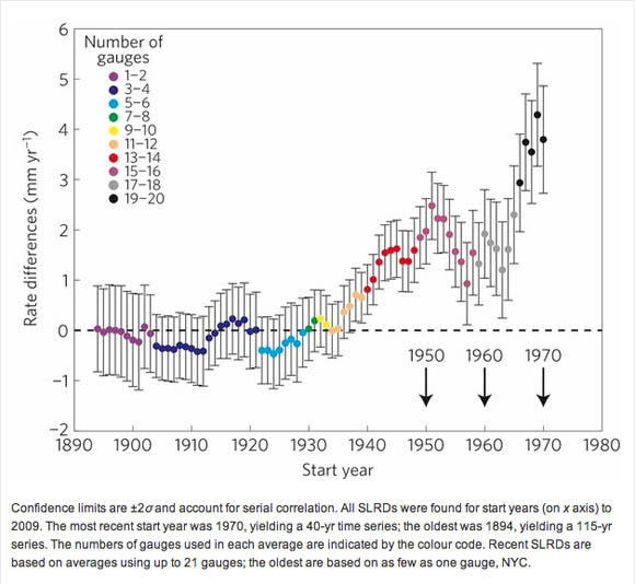
The report's conclusion is succinct: "Our analyses support a recent acceleration of [sea level rise] on ~ 1,000 km of the east coast of North America north of Cape Hatteras," it reads. "This hotspot is consistent with [sea level rise] associated with a slowdown of [the Atlantic Meridional Overturning Current].
That current – usually referred to more pithily as the AMOC – contributes to the warming of the northern latitudes, and cooling of more-equatorial waters. It has been shown to be slowing for some years, causing concern among some climate scientists – for reasons that should be obvious, if one calls such northern climes as, say, the UK home.

Sea-level rate differences (SLRDs) over increasing time sequences show an accelerating rise in sea levels
The AMOC aside, any increase in sea-level rise is a cause for concern in coastal communities. As the report's abstract explaings, "SLR superimposed on storm surge, wave run-up and set-up will increase the vulnerability of coastal cities to flooding, and beaches and wetlands to deterioration."
In other words, it's not just the higher waters that can cause problems, it's those higher waters' activity when under storm stress. As McNutt explains, however, knowledge is power. "As demonstrated in this study," she says, "regional oceanographic contributions must be taken into account in planning for what happens to coastal property."
That opinion is shared by a participant in the West Coast report, Gary Griggs of the University of California at Santa Cruz, who describes the National Research Council's new report, Sea-Level Rise for the Coasts of California, Oregon, and Washington: Past, Present, and Future, as being "intended to provide elected officials, coastal managers, and decision makers with an objective and independent analysis on which they can base future coastal planning."
As with the Eastern seaboard, the NRC report notes that different parts of the globe experience different rates of sea-level rise. What the NRC discovered, and what they detail in the 250-page report, is that there are two distinct zones of sea-level rise on the West Coast of the US, with two distinctly different rates of rise.
From Cape Mendocino – about 250 miles north of San Francisco – southward to the Mexican border, sea level rise is noticeably more pronounced than it is from the same point northward to the Canadian border. The reasons are tectonic.
The southern swatch of the west coast is marked by the Pacific Plate sliding alongside the North American Plate, with very little vertical movement. According to Griggs, this results in sea-level rise on that portion of the coast to be rather consistent with global sea-level rise.
North of Cape Mendocino, however, the Juan de Fuca Plate below the Pacific Ocean is sliding eastward under California, Oregon, and Washington in what's called the Cascadia Subduction Zone. As a result of this subduction, the dry land is slowly rising, resulting in a lower rate of sea-level rise. Some tidal gauges in the area actually show a small drop in sea level over the last century.
As a result, the NRC report contends, sea levels in the more southerly zone will rise by around 2-to-12 inches by 2030 (relative to 2000 levels), 5-to-24 inches by 2050, and 17-to-66 inches by 2100, while in the more northerly zone, sea level rise is projected to be around minus-2-to-plus-9 inches by 2030, minus-1-to-plus-19 by 2050, and 4-to-56 inches by 2100.

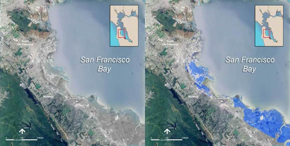
A relatively minor rise in sea level could inundate much of San Francisco International Airport, the NRC notes
As Griggs reasonably points out, the further into the future one attempts to predict sea-level change, the more uncertain those predictions become. That said, the committee producing the NRC paper tasked itself with providing coastal planners with average sea-level rise predictions for planning purposes, and came up with southerly predictions of 6 inches by 2030, 12 inches by 2050, and 36 inches by 2100, and northerly predictions of 2, 6, and 24 inches for the same time periods.
Those northerly predictions, however, could be knocked into a cocked hat for the same reason that the north's sea-level rise is less than the south's: plate tectonics. As the report's "Key Findings" note, "An earthquake magnitude 8 or greater along the Cascadia Subduction Zone would suddenly raise sea level along parts of the coast by an additional 1-2 meters (3-7 feet) over projected levels north of Cape Mendocino."
In addition to that danger, the NRC report notes that some climate models predict a northward shift in the Pacific storm track, which would increase the storm-surge damages also warned about in the USGS report. The NRC, however, concludes that there is not yet enough data to support the northerly storm-shift claims, but adds that "Even if storminess does not increase in the future, sea-level rise will magnify the adverse impact of storm surges and high waves on the coast."
In answer to those Reg readers who might justifiably ask where the IT angle might be in a story about sea-level rise, note that both Oracle and Facebook have their office campuses a mere stone's throw from the steadily rising San Francisco Bay. ®
Bootnote
Although both the USGS and NRC reports are intended to provide guidance to coastal planners, the state of North Carolina is considering a different approach. Instead of relying upon data-based science that indicates increasing rates of sea-level rise, a bill introduced in that East Coast state's General Assembly would simply outlaw any data that might indicate accelerating sea-level rise:
[Rates of sea-level rise] shall only be determined using historical data, and these data shall be limited to the time period following the year 1900. Rates of sea-level rise may be extrapolated linearly to estimate future rates of rise but shall not include scenarios of accelerated rates of sea-level rise.
According to the NRC's Griggs – and many other members of the reality-based community – for the last 20 years, sea levels have been rising at a rate that's about twice as fast as they've risen over the past 100 years.
