Original URL: https://www.theregister.com/2012/03/15/gaga_update_3/
UPDATE: GAGA team hunts down grass-smoking ROBOT
Where in the world is our lawnmower?
Posted in Science, 15th March 2012 14:12 GMT
Poor weather has played havoc with our blade-testing, so the Genuinely Autonomous Garden Assistant (GAGA) team has been focusing on location-tracking technologies, with near-uniformly disappointing results.
Who would have believed that in the first years of the 21st century, a robot going about its business could not be followed with precision by its makers – albeit equipped with minds only marginally superior to theirs. But despite rigorous trials of a range of location-tracking technologies, it's proving deuced difficult to work out where our robot is at any given moment, and so we find ourselves appealing to El Reg readers for additional angles of injury.
Not that we haven't tried. We started by dismissing GPS as overkill – employing billions of dollars of space hardware to locate a lawnmower just seemed excessive. Little did we know that billions of dollars of space hardware were going in fact to prove insufficient to the task.
Our first thoughts were to use a painted pole, spin until the pole appears on a camera display, and then measure the length of the pole to get the distance. NASA used the same technique for testing the Astronaut Manoeuvring Unit – the free-flying astronaut held up a notched stick to measure distance from the shuttle – so if it was good enough for NASA it was probably good enough for us.
Sadly NASA had some distinct advantages, not least the lack of changeable light conditions, the uncluttered background and the competent operator. Our test photographs showed that picking out a coloured pole in a residential setting was a lot harder.
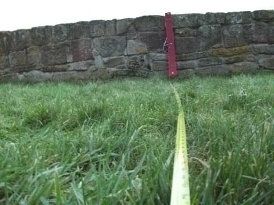
Clever software would probably be able to pick out the vertical bar, but sadly that's beyond our capabilities, and the capabilities of the brain with which we intend to endow GAGA. Better brains for the robot are an option, but sadly better brains for the team are beyond our budget.
The same limitation has prevented us exploiting the one technology which might have been able to answer our needs. Basic radio triangulation is all but impossible thanks to the unreasonably fast speed of light, which requires breathtakingly accurate clocks, not to mention the annoying habit of radio waves to bounce off things and thus arrive later than expected. Ultra wide Band (UWB) radios can be used for triangulation thanks to their very low-power transmissions, and the accuracy is good, but sadly Ubisense wanted £12,000 for an evaluation kit, for which we could probably have employed a gardener.
Cheap and cheerful, but Wi-Fi is also inaccurate
Much cheaper is Wi-Fi positioning, or radio fingerprinting as it's often known. This can make use of existing Wi-Fi infrastructure, accurately measuring the signal strength at different points and compiling a database of "measurers" against locations. That's the technique you see when Wi-Fi positioning is demonstrated various events and at a glance would seem ideally suited to our needs (as the garden is already well-covered for Wi-Fi):
But yet again it all falls apart when one gets down to the details. Wi-Fi is absorbed by water, so humans have a huge impact on the strength of the radio signal. Wi-Fi location solutions firm Ekahau was keen to get involved in the GAGA project, but couldn't promise accuracy greater than five metres, so we'd probably end up mowing the neighbour's car as much as the lawn.
RFID tags were another dead end we explored with all the optimism of enthusiastic amateurs who have no idea what they're doing. Such tags are very short range, a dozen centimetres or so, but they are cheap and induction-powered – and so could be pushed into the turf to provide precise location information to a reader mounted under the robot. It's not ideal, but it sounds feasible until one starts looking at the mathematics: a lawn measuring 30m by 20m has 600m2 of turf, each square metre of which contains 25 squares measuring 20cm each side (so a tag in the centre could be read). So now we're pushing 15,000 tags into the lawn, which might be possible, but certainly isn't very practical.
It would be a lot easier if one could read the strength of an RFID signal, and then use a higher-power reader to read multiple tags – and in that way establish a radio fingerprint database of the garden. Unfortunately we've not been able to find any hardware which will report the signal strength of an RFID tag, but pointers are welcome.
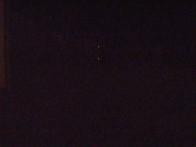
At about this point we decided to try measuring distance again, this time using coloured LEDs in the hope they'd be easier to spot during the analysis even if it meant we could only mow the lawn at night. Turns out the colours don't really travel:
So back to RFID tags. We might well use a few, to let the robot know when it's reached key locations, and we also considered them an ideal way to get around the chief limitation of GPS (which was starting to look like the most sensible option), though it turns out the chief limitation wasn't the only limitation.
The rise, and fall, of GPS positioning
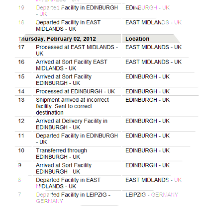
We ordered a GlobalSat MR-350 waterproof GPS receiver, which ironically had a terrible time reaching us from Expansys (though, to be fair, it was DHL's fault as they shipped it repeatedly to Edinburgh and then decided that the weather was too bad for the package to reach the Scottish Highlands – despite the fact that the only snow we'd had here during the big freeze last month wasn't enough to fill an ice tray).
Our GPS kit spends a few days knocking around Edinburgh before settling in Inverness for a few days to wait for the snow which would justify its delay
Irony aside, there are distinct problems with the Global Positioning System, which would appear to make it almost entirely incapable of meeting our needs.
GPS works by picking up the time from satellites, and using that time to measure how far away they are. The satellites carry the heroically accurate clocks, and the distances involved are great enough to allow comparative measurements – if only the speed of light weren't so damned variable.
The absolute constant, c, is only constant in a vacuum, and while the majority of the signal's journey to earth is completed within a vacuum, the last bit has to penetrate our soupy nitrogen/oxygen atmosphere where the speed of light (and thus radio) varies depending on the pressure - that is to say, GPS is horribly weather-dependent.
This can be addressed through the use of Differential GPS. Differential systems start with a known location, often a lighthouse or similar, and fit a decent GPS receiver there. The difference between the known location and the GPS fix at that location is then transmitted across the ground, at around 300kHz, so a GPS receiver which can pick up the Differential signal can modify its own results by the same amount to account for atmospheric distortion.
Sadly our test site lies bang between the two Scottish Differential transmitters, at Aberdeen and the northern tip of Lewis, around 160km from either. According to the US Federal Navigation Plan, Differential GPS can drift by 67cm for every 100km of distance, so at the very best we'd have an accuracy of around 1m, that is, if we could actually pick up the Differential signal at all – unfortunately it seems that the mountains between our test site and either transmitter make Differential GPS another dead end.
It is possible to create a local Differential signal, as the farmers of East Anglia have done, but East Anglia isn't significantly more hilly than the open sea, and is also a very long way from us, so some sort of local solution is necessary.
It occurred to us we could create our own differential: using two GPS receivers, one stationary and the other mounted on the robot, we could subtract the stationary from the moving to create a relative position, which is all we need.
The GSP receivers communicate using RS232. The exact protocol costs £400 to buy, but there are enough documented examples to enable basic functionality without needing the exact specs. A pair of MR-350s were connected up and monitored to test the idea, but to our horror we hadn't even started either of them moving when we were able to watch as they happily reported colliding, and eventually passing through each other, within minutes – all while absolutely stationary and standing more than two metres apart.
Clearly cheap GPS kit wasn't going to suffice, so we upgraded to a Garmin 10x-5Hz costing well over a ton, and watched to see how consistent it would be in picking up the signal.
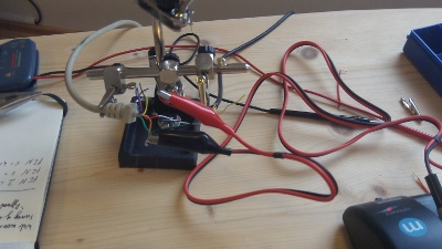
Fortunately Garmin supports the industry-standard crocodile-clip-and-twisted-wire interface
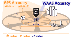
But that too drifted by a handful of metres while being watched, and to be fair Garmin does state that even when a Differential signal is available one shouldn't expect accuracy better than three metres.
So we are left without a way of locating our robot, lost in a sea of lawn and unable to find its way home. We could, of course, concede that intelligence should be limited to those with flesh around their bones, and just build something which bounces around the garden, but that seems like cheating so we're opening the floor to suggestions for better navigation technologies.
Meanwhile we'll get on with finding the best way to hack through the growth. Several people pointed out that our 6,000 rpm motor wasn't up to the job of whisking plastic blades through the grass, so a 10,000 rpm motor was obtained and testing continues, but at the moment the winning technology is a bloody great chunk of metal with a sharpened edge: