US town tells Street View to push off
Private community snaps removed from Google Maps
What you need to know about cloud backup
Google has removed a private Minnesota community from its Street View feature after the town politely asked the search monolith to keep its roving spycars to itself.
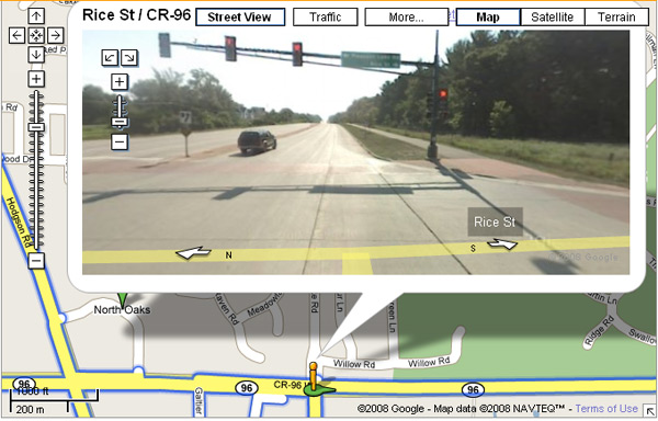
North Oaks, north east of Minneapolis, boasts a "unique situation", the Minnesota Star Tribune reports, in that its roads are owned by the residents and it "enforces a trespassing ordinance". The North Oaks City Council sent Google a letter back in January asking for erasure from Street View, and the company quickly complied:

Mayor Thomas Watson explained: "It's not the hoity-toity folks trying to figure out how to keep the world away. They really didn't have any authorization to go on private property."
Google spokswoman Elaine Filadelfo said the Street View driver "likely didn't see North Oaks' no-trespassing signs", and confirmed: "Certainly private roads are something we take seriously."
Google is coming under increasing pressure to address the Street View privacy issue. Mr and Mrs Boring of Pittsburgh recently accused the company of "photographing their swimming pool and posting it to the web"; while the Pentagon got rather annoyed with photographs of Fort Sam Houston.
The company has a "delete-on-request" service for individuals caught on camera, and last month deployed some experimental face-blurring tech on images of New York shortly after admitting privacy could be a bigger issue in Europe than in the US as it began to prowl the streets of several European cities. ®
COMMENTS
@lamfanboy What's the point?
Emergence.
One of the things that is interesting about Google is that it provides this for free. It takes us closer to the enhanced reality where a locational cross-reference can trigger relevant searches or events. User uploaded comments and content, traditional queries into the Google indexes, and immersive photoreality can combine very quickly to be much more than the sum of the parts. It may seem ho-hum now, but combine all this with a compass in a handheld device, and suddenly you have something very interesting...X-Ray vision from the other side of a wall or building anyone? What about a pair of goggles with directional location sensing? Think about this for military or emergency services. Hell, think about gaming using the real world as a map! Virtual tourism. All this is static, but it is not a quantum leap in technology to provide more real time immersion if the feeds were fast enough.
For more on this sort of thing, look at where Photosynth and Sea Dragon are. I think the way I found this was originally an article here on El Reg. You are looking for the TIM podcast. Visit the Microsoft website for an online demo.
Expect a less page oriented future in other words, and more immersive applications of this technology.
RE: Whats the point
"There are plenty of applications for it and every time you use it Google can show you some ads for businesses also in the area."
Ooooo goody more Ads!!! :(
RE: What's the point?
Well one point could be directions. Direction websites have been around for a long time but it makes it all that easier if there is a photo of the alley that you need to turn down, or a picture of the building.
Extend this to GPS and rather than having just the normal 3D view you have a photo realistic view.
Then, you want to buy a house in the neighbourhood. You can visit it virtually first.
There are plenty of applications for it and every time you use it Google can show you some ads for businesses also in the area.

IT infrastructure monitoring strategies
What you need to know about cloud backup
Enabling efficient data center monitoring
Agentless Backup is Not a Myth
Top 10 SIEM implementer’s checklist