Original URL: https://www.theregister.com/2006/01/17/google-earth-investigation/
Google Earth: the photo interpretation challenge
WMDS and black helicopter facilities
Posted in Science, 17th January 2006 16:26 GMT
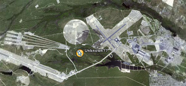
There's some light entertainment this afternoon courtesy of a couple of readers who have spotted further strangeness on Google Earth. First up is Stuart Dempsey, who asks "what the hell?" is this place all about:

Paul Van Den Steene of Brussels, meanwhile, thinks he may have succeeded where the CIA failed and found one of Saddam Hussein's famed Weapons of Mass Destruction™:

Interesting stuff, which got us thinking of the old days before Google Earth when if you wanted a aerial picture of something some chap had to get into a Spitfire or such like and nip over and grab it on film.
One of the best examples, we reckon, is the allied aerial reconnaissance material of the Nazi secret research facility at Peenemunde on Germany's Baltic coast. Back then they had teams of highly-trained operatives poring over photos with magnifying glasses trying to work out just what Adolf was up too. Tricky work, as this image shows:

Well, what would you have made of it? By 1943, the RAF had made enough of it to produce this bombing map:

To have a look at Peenemunde now on Google Earth (with the bombing map overlaid - a nice touch provided by Google Earth Hacks) - try this .kmz link. Bear in mind that most of the wartime facilities are now gone - systematically destroyed by the Russians.
If you compare the reconnaissance snap with the map, you'll see just how little info the bomber crews were provided with. This is either by design, since the government didn't want it getting about that the Nazis were developing a rocket capable of hitting London, or because they simply didn't know exactly what was going on.
Try the structure marked "A" on the bombing map, though, and then have a closer look on the photo (marked "A1" by the RAF - that's our big white arrow). In fact, the allies already had a pretty good idea what the "experimental station" in question actually was.
More conclusive evidence of Nazi activity at Peenemunde came with images such as this one: a close-up of the aforementioned "experimental station":

Yup, the photo interpretation department has correctly identified a V-2 lying on its side (arrowed). There's more evidence of rocket activity in there, too, if you look closely.
 In the event, that was more than enough for Bomber Command to dispatch 597 aircraft on 17-18 August 1943. The results of the raid on the V-2 launchpad can be seen here. Despite the huge raid - during which 40 aircraft were lost - the V-2 programme was delayed only by around two months. The first rocket to hit the UK subsequently hit Staveley Road, Chiswick, London on on Friday 8 September 1944 - the taster of a total of 1,300 V-2s to hit England.
So, back to our mystery location. Given the same resources available our WW2 compatriots, what would we be able to make of the features marked A, B, C, D and E?

Ok, that's a little unfair - let's say the photo recon boys managed to get a bit lower...


For the record, D is more of a "what happened here?" than a "what is this?", and we can now reveal that...
... or rather we can't, because if we did, how would you lot get your afternoon's entertainment?
Nope, it's up to you lot to interpret the evidence. We reckon we've got it cracked and it took us just 30 minutes to identify all the features/facilities shown without any prior knowledge. Mind you, we've got the internet on our side, which is something they didn't have back in 1943, and we also had the original .kmz reference, which made it pretty straightforward.
No such luck for you lot. Suffice it to say the facility is in the US of A. No prizes here - just a bit of fun, but let's see how quickly you can set Stuart Dempsey straight. Don't forget Saddam Hussein's menacing WMD, either. Any ideas? Full answers tomorrow.
And, finally, speaking of fun, here's the latest reader self-sighting on Google Earth. The attached photographic evidence - allegedly taken on the same day as the Google satellite passed over - is pretty compelling, we must say:

Thanks very much too Mark Ahern for that. By our reckoning, Mark lives in the mountains somewhere to the east of the Chinese town of Urumqi. Looks pretty cold out there mate - wrap up warm. ®